


Color Plotter
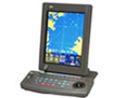
Color Plotter
1.The JLZ-700 color plotter is designed with the most advanced technology in mind to provide the most convenient operation for the user. The detailed coastline information includes landmarks such as geographic names, allowing easy check on own ship’s current position and fishing grounds. Various types of information including the topographic features of sea bottoms, user data on fishing grounds and navigational information can be displayed using JRC’s unique marks, symbols and lines such as for example, for a fish-breeding reef, sunken ship, sea bottom topology or prohibited district. The cursor operation using a trackball allows any mark or symbol to be entered on the display in an easy way. The display can be enlarged, scaled or scrolled easily at high speed. While watching the coastlines and fishing ground data, you can search for a target fishing ground swiftly. JLZ-700 has a function dimmable, you can adjust the brightness of the display according to preference now. The optional JRC Differential Global Positioning System Receiver can be directly connected to the JLZ-700 Color Plotter to accurately reach a few meters to ensure your exact position.
The JLZ-700 echo sounder includes a processor and a keyboard (optional with a 10.4-inch LCD display) for flexible installation in confined spaces. You can rotate and tilt the 10.4" optional LCD display for the best viewing angle. With the optional RGB video output (CAD-239), one processor can be connected two monitors.
The JLZ-700 color plotter connected to a GPS or DGPS receiver can display the ship’s own position, trail, waypoints, destination and coastlines in color in an easy-to-see screen. The JLZ-700 is a very useful tool for enhancing your efficiency of fishing operations and safety of navigation.
The JLZ-700 is designed to maximize your ease of use and supports C-Map NT+ drawing capabilities (optional).
HOME | NEWS | Product Center | Solution | Case Presentation | Service Centre | About us
Tianjin Ocean Telecom Technology Co., Ltd. Tel: 022-25859385 E-mail:tjhysm@126.com Address:5th Floor, No. 50A, Bohai Road, Economic and Technological Development Zone, Binhai New Area, Tianjin | 
天津大海电信科技有限公司 津ICP备13000197号 版权所有 技术支持:大海电信 |