


The new JLR-7500/JLR-7800 (D)GPS navigator
The new JLR-7500/JLR-7800 (D)GPS navigator
1.The new JLR-7500/JLR-7800 (D)GPS navigator will locate your position accurately and gives you a wide range of possibilities – integrated with the latest technologies – that will enhance your operational performance.
One of the new display modes is the 3D highway, which allows you to intuitively view the location of the next waypoint. This 3D guidance is particularly valuable to follow a real-time chain of waypoints along a planned route.
The new (D)GPS navigator allows you to plan long distance routes highly effective. It is possible to set Rhumb lines (RL) for short legs, while Great Circle (GC) can be set for the long-distance legs – all possible within the same route. Simply make your selection for each leg to reach your destination effortlessly.
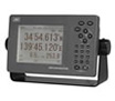
All information is displayed on a highly visible 5.7-inch LCD display, featuring added sharpness and contrast compared to the previous version. Many display modes are readily available and selectable from the menu, such as navigation, CDI, highway, track plotting and service and information screens. The display has four dim modes, allowing adjusting at your own convenience.
The new display design allows you to carry out all operations simply by using the unified keyboard layout. The keyboard is solid and responsive, which allows for precise operation. The keys are also backlit, making it easy to operate in low-light settings on the bridge. The compact design of the JLR-7500/JLR-7800 incorporates a new intuitive interface, providing enhanced ergonomics and user friendliness. The logic of the controls and excellent on-screen menus will greatly shorten most users’ learning period.
With the new (D)GPS navigator, entering data is just as simple as creating a (SMS) text message on your phone. The consistency in the keyboard layout allows entering waypoint data fast and in a natural way.
The newly developed sensors include RAIM, which is to access the integrity of GPS signals. If multiple satellite signals are picked up, this system will check if the position fix is consistent with the computed position, assuring higher reliability than conventional methods.
HOME | NEWS | Product Center | Solution | Case Presentation | Service Centre | About us
Tianjin Ocean Telecom Technology Co., Ltd. Tel: 022-25859385 E-mail:tjhysm@126.com Address:5th Floor, No. 50A, Bohai Road, Economic and Technological Development Zone, Binhai New Area, Tianjin | 
天津大海电信科技有限公司 津ICP备13000197号 版权所有 技术支持:大海电信 |