


Chart Radar
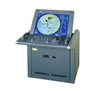
Chart Radar
1.The JMA-900M chart radar is a radar system with an Electronic Chart Display and Information System (ECDIS) that seamlessly displays all the information you need on the same screen for easy operation. This solution is used to monitor navigation-related information, navigation routes, and vessel conditions to effectively reduce the human factors in stranding or impact.
The basic radar specifications and scanner types of the JMA-900M series are identical to JRC’s famous JMA-9900 radar series. This system was developed to improve radar performance, with user-friendly operation and high visibility, and compliance with International Maritime Organization (IMO) performance standards and regulatory requirements. The Electronic Chart Display and Information System provides information from the official Electronic Navigational Chart (ENC), the Global Positioning System (GPS) and the Automatic Ship Identification System (AIS).
Chart radar can use the official system electronic nautical chart (SENC) which is equivalent to the latest paper chart. The System Electronic Navigation Chart (SENC) also maintains additional information obtained from other sources. The operator can modify the information that is always required to be displayed on the chart in all geographic locations and cases to the system’s electronic chart.
The Automatic Ship Identification System (AIS) is an important onboard navigation device to prevent impact and navigation. Information from other vessel broadcasts will be displayed along with geographic information on the radar system or Electronic Chart Display and Information System (ECDIS), providing highly applicable data for strategic decision making and immediate contact with other vessels. The AIS target will not be shielded by ground, rain or cloud reflections, nor will it be eliminated due to sea clutter or rain clutter adjustments. At the same time, you can easily switch between different AIS target symbols. Automatic radar mapping (ARPA) targets are displayed on the same radar/electronic chart display and information system screen. It is very useful to compare these targets because it gives you an overview of the navigation of other vessels for safe and efficient navigation.
HOME | NEWS | Product Center | Solution | Case Presentation | Service Centre | About us
Tianjin Ocean Telecom Technology Co., Ltd. Tel: 022-25859385 E-mail:tjhysm@126.com Address:5th Floor, No. 50A, Bohai Road, Economic and Technological Development Zone, Binhai New Area, Tianjin | 
天津大海电信科技有限公司 津ICP备13000197号 版权所有 技术支持:大海电信 |