

GPSMAP® 1022
GPSMAP® 1022
Ø 10-inch color display with keypad interface and multifunction control knob
Ø High-sensitivity internal 10 Hz GPS and GLONASS receiver
Ø Fully network capable for Garmin Marine Network and NMEA 2000® plus NMEA 0183 support
Ø Supports optional BlueChart® g2 Vision® HD charts for Auto Guidance and other premium navigation features
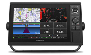
The GPSMAP1022 uses a 10-inch high-definition display that automatically adapts to the environment to change brightness and is easy to read, with a quick and easy-to-use keypad interface with user-programmable keys and a multifunction control knob for convenient control. It is a high-performance integrated multi-function navigator for high-speed cruise boats, yachts and sailboats.
![]()
![]()
Ø Full-network compatibility
Garmin Marine Network support allows sharing of sonar, including Panoptix sonar, maps, user data, Garmin radar and IP cameras among multiple units. Plus, there’s NMEA 2000 and NMEA 0183 support for connectivity, including autopilots, digital switching, weather, FUSION-Link, VHF, AIS and other sensors.
![]()
![]()
Ø Built-in Wi-Fi connection
Built-in Wi-Fi connectivity for easy access to and use of BlueChart Mobile 2.0 and Garmin Helm apps. Garmin Helm allows you to view and control compatible navigators through a compatible smartphone or tablet while enhancing the driver's perception of the surrounding environment. BlueChart Mobile 2.0 is a free app downloaded from the App StoreTM. You can make a planned route on your iPad or iPhone, then wirelessly transfer this information to the ship's compatible Garmin navigator and get the latest weather information via the mobile network and transfer it to your navigator. You can also control the VIRB motion camera over the wireless network and get real-time shots.
Ø Built-in ANT® Connectivity
Enjoy built-in ANT wireless connectivity directly to quatix® marine watch, Garmin Nautix™ in-view display, gWind™ Wireless 2 transducer, GNX™ Wind marine instrument and wireless remote controls.
Ø Heading and Position Refreshed 10 Times per Second
Fast, responsive built-in 10 Hz GPS receiver refreshes your position and heading 10 times each second to make your movement on the screen more fluid. It makes dropping up to 5,000 accurate waypoints -- and finding your way back to them -- quick and easy.
![]()
Ø Upgrade to Our Best Maps on the Water
Include expandable memory for accessory map purchases, such as LakeVü HD Ultra with Max Def Lakes or BlueChart g2 Vision HD, which adds Garmin patented Auto Guidance and other great features.
![]()
Ø SailAssist Features
To help you gain a wind-maximizing competitive edge, your chartplotter features a pre-race guidance page that shows your virtual starting line along with data fields showing laylines, time to burn before the start and a race timer that can be synchronized across all your networked Garmin GPS products. In addition, other supported sailing features include true and apparent wind angle, set and drift, true or apparent wind speed, horizontal or vertical graphs and a data bar with customizable data fields.
Ø GPX Waypoints Transfer
If you have waypoints, tracks or frequently used routes stored on another manufacturer’s GPS product -- or on a Garmin handheld device -- it’s easy to transfer those items to your new Garmin chartplotter via industry-standard GPX software formatting.
Auto Guidance is for planning purposes only and does not replace safe navigation operations.
HOME | NEWS | Product Center | Solution | Case Presentation | Service Centre | About us
Tianjin Ocean Telecom Technology Co., Ltd. Tel: 022-25859385 E-mail:tjhysm@126.com Address:5th Floor, No. 50A, Bohai Road, Economic and Technological Development Zone, Binhai New Area, Tianjin | 
天津大海电信科技有限公司 津ICP备13000197号 版权所有 技术支持:大海电信 |